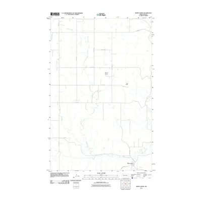
2011 Map of White Earth
USGS Topo · Published 2011About this map
White Earth anchors this rural North Dakota landscape, situated along the winding course of the White Earth River. The 2011 survey reveals an environment defined by the intersection of traditional topography and modern energy extraction, notably the White Earth Oil and Gas Field centrally located in the quadrangle. The terrain is marked by significant elevations like Big Butte and a network of drainages including the extensive Paulsen Creek, which meanders across the section lines toward the river. Transportation throughout the region relies on a rigid grid of rural roads, such as 101st Ave NW and 74th St NW, connecting isolated homesteads to larger thoroughfares like County Hwy 3011. This map documents the early 21st-century development of the Bakken region, where the oil industry has integrated into the rolling prairie landscape.
Find a feature on this map
18 named features on this map. Tap any name to fly to it.
Don’t see what you’re looking for? This feature index may not catch every label — zoom into the map to look around manually.
Map Details
Editions of this 2011 White Earth Map
This is the sole edition of this map. No revisions or reprints were ever made.
Other maps of this area

1953 · Williston
USGS Topo · 1:250,000

1957 · Williston
USGS Topo · 1:250,000

1969 · Ross NW
USGS Topo · 1:24,000

1969 · White Earth
USGS Topo · 1:24,000

1974 · McGregor
USGS Topo · 1:24,000

1977 · Powers Lake
USGS Topo · 1:24,000

1978 · Battleview
USGS Topo · 1:24,000

1979 · Tioga SE
USGS Topo · 1:24,000
1979 · Tioga SW
USGS Topo · 1:24,000
1979 · Tioga
USGS Topo · 1:24,000