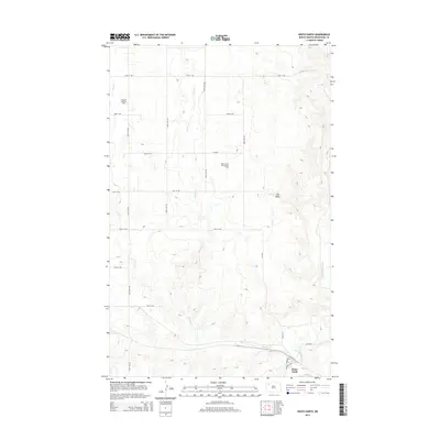
2014 Map of White Earth
USGS Topo · Published 2014About this map
White Earth occupies the lower corner of this Mountrail County landscape, situated near the confluence of Paulsen Cr and the White Earth River. The region is defined by the energy industry of the Bakken formation era, characterized by the expansive Tioga Oil and Gas Field to the northwest and the White Earth Oil and Gas Field centrally located. The terrain is marked by a network of sectional roads such as 74th St NW and 101st Ave NW, which provide access to the various wells and drilling sites across the prairie. Rising above the industrial landscape, Big Butte stands as a prominent elevation point in the eastern portion of the survey. The settlement of White Earth is reached via Metmish Ave, serving as a local hub for the surrounding ranching and oil extraction operations.
Find a feature on this map
21 named features on this map. Tap any name to fly to it.
Don’t see what you’re looking for? This feature index may not catch every label — zoom into the map to look around manually.
Map Details
Editions of this 2014 White Earth Map
This is the sole edition of this map. No revisions or reprints were ever made.
Other maps of this area

1953 · Williston
USGS Topo · 1:250,000

1957 · Williston
USGS Topo · 1:250,000

1969 · Ross NW
USGS Topo · 1:24,000

1969 · White Earth
USGS Topo · 1:24,000

1974 · McGregor
USGS Topo · 1:24,000

1977 · Powers Lake
USGS Topo · 1:24,000

1978 · Battleview
USGS Topo · 1:24,000

1979 · Tioga SE
USGS Topo · 1:24,000
1979 · Tioga SW
USGS Topo · 1:24,000
1979 · Tioga
USGS Topo · 1:24,000