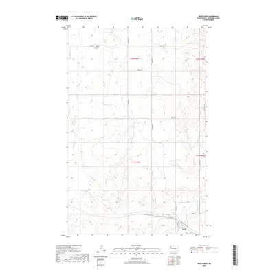
2020 Map of White Earth
USGS Topo · Published 2020About this map
White Earth lies at the southern edge of this survey, situated near the winding course of the White Earth River. The surrounding landscape of Mountrail County is defined by the high point of Big Butte and the drainage of Paulsen Cr, which cuts through the prairie terrain. Rural life and the community's heritage are anchored by the Norman Lutheran Cem in the northern portion of the quadrangle, reflecting the early settlement patterns of the region. The map captures a grid of rural roads like 74th St NW and 100th Ave NW that serve the agricultural townships of T158N R94W and T157N R94W. This layout illustrates the persistence of the section-line road system in North Dakota, providing a clear view of the land divisions and remote homestead locations as they existed in the early 21st century.
Find a feature on this map
23 named features on this map. Tap any name to fly to it.
Don’t see what you’re looking for? This feature index may not catch every label — zoom into the map to look around manually.
Map Details
Editions of this 2020 White Earth Map
This is the sole edition of this map. No revisions or reprints were ever made.
Other maps of this area

1953 · Williston
USGS Topo · 1:250,000

1957 · Williston
USGS Topo · 1:250,000

1969 · Ross NW
USGS Topo · 1:24,000

1969 · White Earth
USGS Topo · 1:24,000

1974 · McGregor
USGS Topo · 1:24,000

1977 · Powers Lake
USGS Topo · 1:24,000

1978 · Battleview
USGS Topo · 1:24,000

1979 · Tioga SE
USGS Topo · 1:24,000
1979 · Tioga SW
USGS Topo · 1:24,000
1979 · Tioga
USGS Topo · 1:24,000