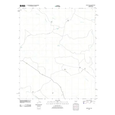
2010 Map of White Flat
USGS Topo · Published 2010About this map
The arid high plains of Chaves County are defined here by a network of drainage features and remote ranching outposts in the early 21st century. The landscape is dominated by the Middle Arroyo, which winds through the northern and eastern portions of the map, supported by vital water sources like Big Joe Tank, Little Joe Tank, and Browns Lake. These infrastructure points illustrate the essential nature of water management for livestock in this environment. Scattered cattle operations, including the Middle Arroyo Ranch, White Flat Ranch, and Lowrey Ranch, serve as the primary human nodes connected by a sparse grid of roads such as County Rd-B029 and White Flat Rd. To the south, the terrain rises toward Cedar Hill, while the Zeufeldt Arroyo and Salt Creek manage runoff in the lower reaches of the quadrangle.
Find a feature on this map
21 named features on this map. Tap any name to fly to it.
Don’t see what you’re looking for? This feature index may not catch every label — zoom into the map to look around manually.
Map Details
Editions of this 2010 White Flat Map
This is the sole edition of this map. No revisions or reprints were ever made.
Other maps of this area

1936 · Arabela
USGS Topo · 1:48,000

1942 · Arabela
USGS Topo · 1:62,500

1955 · Roswell
USGS Topo · 1:250,000

1958 · Roswell
USGS Topo · 1:250,000

1962 · Roswell
USGS Topo · 1:250,000

1967 · Round Mountain SE
USGS Topo · 1:24,000

1967 · North Lake
USGS Topo · 1:24,000

1967 · White Flat
USGS Topo · 1:24,000
1967 · White Flat SE
USGS Topo · 1:24,000
1967 · Elsie Canyon
USGS Topo · 1:24,000