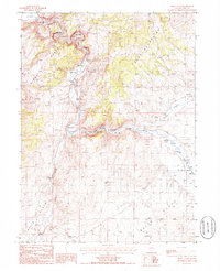
1985 Map of White Flats
USGS Topo · Published 1986About this map
The California Emigrant Trail and the historic Hastings Cut-Off converge along the South Fork Humboldt River, marking this landscape as a vital corridor for westward migration. This 1980s-era topographical study reveals the complex terrain where the Pinon Range and Elko Mountains overlook the broad alluvial basin of White Flats. The irrigation and water management needs of the high desert are evident in the presence of a Siphon, a Gaging Station, and numerous sandpits near the riverbanks. The settlement of Corral and various ranching features sit between Tenmile Creek and Dixie Creek, illustrating how the region's limited water sources dictated the layout of local agriculture and transportation during the late 20th century.
Find a feature on this map
16 named features on this map. Tap any name to fly to it.
Don’t see what you’re looking for? This feature index may not catch every label — zoom into the map to look around manually.
Map Details
Editions of this 1985 White Flats Map
This is the sole edition of this map. No revisions or reprints were ever made.
Other maps of this area

1952 · Dixie Flats
USGS Topo · 1:62,500

1955 · Elko
USGS Topo · 1:250,000

1957 · Elko West
USGS Topo · 1:24,000

1957 · Elko East
USGS Topo · 1:24,000

1958 · Elko
USGS Topo · 1:250,000

1958 · Hunter
USGS Topo · 1:24,000

1962 · Elko
USGS Topo · 1:250,000
1962 · Hunter
USGS Topo · 1:24,000
1962 · Elko East
USGS Topo · 1:24,000
1962 · Elko West
USGS Topo · 1:24,000