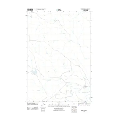
2012 Map of White Horse
USGS Topo · Published 2012About this map
The Moreau River and its tributary, the Little Moreau River, define the southern landscape of this Dewey County region. The community of Whitehorse is situated near the confluence of these waterways, serving as a focal point in a territory characterized by extensive drainage systems including Dog Butte Cr and Whitehorse Cr. This 2012 survey illustrates the sparse road network typical of the plains, where significant routes like Whitehorse Rd and On The Tree Rd provide the primary links between isolated settlements and water sources like Whitehorse Lake. The topography reveals the intricate erosion patterns of the northern prairie, with the river valleys cutting through the high ground in an area historically significant for its tribal and ranching heritage.
Find a feature on this map
8 named features on this map. Tap any name to fly to it.
Don’t see what you’re looking for? This feature index may not catch every label — zoom into the map to look around manually.
Map Details
Editions of this 2012 White Horse Map
This is the sole edition of this map. No revisions or reprints were ever made.
Other maps of this area

1951 · Ridgeview NW
USGS Topo · 1:24,000

1951 · Ridgeview NE
USGS Topo · 1:24,000

1952 · Whitehorse
USGS Topo · 1:24,000

1952 · Parade NE
USGS Topo · 1:24,000

1952 · Glencross SE
USGS Topo · 1:24,000

1953 · McIntosh
USGS Topo · 1:250,000

1958 · McIntosh
USGS Topo · 1:250,000

1975 · Glencross
USGS Topo · 1:24,000
1975 · Glencross NE
USGS Topo · 1:24,000

1978 · Timber Lake
USGS Topo · 1:24,000