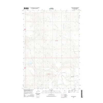
2015 Map of White Horse
USGS Topo · Published 2015About this map
The community of Whitehorse sits above the confluence of two significant waterways in Dewey County, where the Little Moreau River joins the main stem of the Moreau River. This 2015 survey illustrates a landscape of high prairie plateaus and intricate drainage systems, most notably defined by the long, winding path of Whitehorse Cr as it descends from the north and Dog Butte Cr which carves through the central hills. The presence of Whitehorse Lake in the western portion of the quadrangle provides a localized water source within the typically arid upland terrain. Transportation across this rural expanse is facilitated by a network of Bureau of Indian Affairs routes, including Bia-2 and Bia-3, alongside CR-7, which together connect the isolated settlement to the broader region.
Find a feature on this map
13 named features on this map. Tap any name to fly to it.
Don’t see what you’re looking for? This feature index may not catch every label — zoom into the map to look around manually.
Map Details
Editions of this 2015 White Horse Map
This is the sole edition of this map. No revisions or reprints were ever made.
Other maps of this area

1951 · Ridgeview NW
USGS Topo · 1:24,000

1951 · Ridgeview NE
USGS Topo · 1:24,000

1952 · Whitehorse
USGS Topo · 1:24,000

1952 · Parade NE
USGS Topo · 1:24,000

1952 · Glencross SE
USGS Topo · 1:24,000

1953 · McIntosh
USGS Topo · 1:250,000

1958 · McIntosh
USGS Topo · 1:250,000

1975 · Glencross
USGS Topo · 1:24,000
1975 · Glencross NE
USGS Topo · 1:24,000

1978 · Timber Lake
USGS Topo · 1:24,000