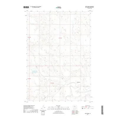
2017 Map of White Horse
USGS Topo · Published 2017About this map
The Moreau River and Little Moreau River converge in this Dewey County landscape, defining the topography near the settlement of Whitehorse. The terrain is characterized by the complex drainage systems of Whitehorse Cr and Dog Butte Cr, which carve into the plains of the Cheyenne River Reservation. Transportation in this part of South Dakota is largely defined by rural routes such as BIA Hwy 4 and the descriptively named On The Tree Rd. A prominent water feature, Whitehorse Lake, sits to the west of the main townsite. This survey provides a clear view of the cadastral grid, marked by township boundaries like t16n r26e and t15n r26e, which organize the sparsely populated cattle country and river bottomlands during the early twenty-first century.
Find a feature on this map
13 named features on this map. Tap any name to fly to it.
Don’t see what you’re looking for? This feature index may not catch every label — zoom into the map to look around manually.
Map Details
Editions of this 2017 White Horse Map
This is the sole edition of this map. No revisions or reprints were ever made.
Other maps of this area

1951 · Ridgeview NW
USGS Topo · 1:24,000

1951 · Ridgeview NE
USGS Topo · 1:24,000

1952 · Whitehorse
USGS Topo · 1:24,000

1952 · Parade NE
USGS Topo · 1:24,000

1952 · Glencross SE
USGS Topo · 1:24,000

1953 · McIntosh
USGS Topo · 1:250,000

1958 · McIntosh
USGS Topo · 1:250,000

1975 · Glencross
USGS Topo · 1:24,000
1975 · Glencross NE
USGS Topo · 1:24,000

1978 · Timber Lake
USGS Topo · 1:24,000