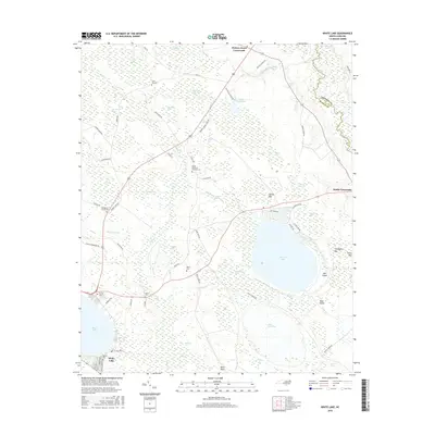
2016 Map of White Lake
USGS Topo · Published 2016About this map
Bay Tree Lake and its surrounding Carolina bays dominate this eastern portion of Bladen County, showcasing the unique elliptical wetland depressions characteristic of the coastal plain. The landscape is defined by these natural basins, including the extensive Beaver Dam Bay to the northwest. Human settlement is concentrated at historic junctions such as Hickory Grove Crossroads and Smith Crossroads, where local road networks meet the area's agricultural and timber lands. The eastern edge of the survey transitions into the low-lying terrain near the South River, featuring distinct landforms like Mill Island and Boat Island. These features illustrate the complex hydrology and drainage patterns of the region, where swampy tracts and higher ridges have long dictated the placement of homesteads and connecting routes.
Find a feature on this map
6 named features on this map. Tap any name to fly to it.
Don’t see what you’re looking for? This feature index may not catch every label — zoom into the map to look around manually.
Map Details
Editions of this 2016 White Lake Map
This is the sole edition of this map. No revisions or reprints were ever made.
Other maps of this area

1953 · Florence
USGS Topo · 1:250,000

1954 · Florence
USGS Topo · 1:250,000

1954 · White Lake
USGS Topo · 1:62,500

1955 · Elizabethtown
USGS Topo · 1:62,500

1959 · Roseboro
USGS Topo · 1:62,500

1959 · Garland
USGS Topo · 1:62,500

1982 · Elizabethtown
USGS Topo · 1:100,000
1986 · Ingold
USGS Topo · 1:24,000
1986 · Garland
USGS Topo · 1:24,000
1986 · Singletary Lake
USGS Topo · 1:24,000