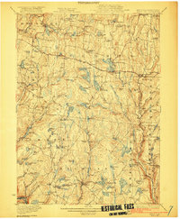
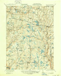
1922 Map of White Lake
USGS Topo · Published 1922About this map
White Lake and the surrounding Sullivan County landscape are defined by a dense network of glacial water bodies and early 20th-century rural outposts. Settlement is concentrated in small hubs like Bethel, Eldred, and Fosterdale, while the countryside is dotted with one-room schoolhouses such as Birch Ridge School, Hurd School, and Wellstown School. The presence of the Plank Road running north-south through Thompson and early industrial markers like Bacas Mill and Falls Mill speak to a local economy once rooted in timber and milling. The terrain is notably varied, moving from the wetlands of Deep Hollow Swamp and Grassy Swamp Pond to heights like Nigger Hill and Round Top. For those tracing ancestry, the map preserves specific cultural enclaves like Dutch Settlement and family-linked landmarks such as the Stewart Cemetery, showing the region before the modern era of development.
Find a feature on this map
87 named features on this map. Tap any name to fly to it.
Don’t see what you’re looking for? This feature index may not catch every label — zoom into the map to look around manually.
Map Details
Editions of this 1922 White Lake Map
6 editions found

Other maps of this area

1906 · Port Jervis
USGS Topo · 1:62,500

1908 · Port Jervis
USGS Topo · 1:62,500

1909 · Monticello
USGS Topo · 1:62,500

1910 · Neversink
USGS Topo · 1:62,500

1911 · Monticello
USGS Topo · 1:62,500

1913 · Milford
USGS Topo · 1:62,500

1915 · Milford
USGS Topo · 1:62,500

1920 · Long Eddy
USGS Topo · 1:62,500

1920 · Damascus
USGS Topo · 1:62,500

1921 · Long Eddy
USGS Topo · 1:48,000