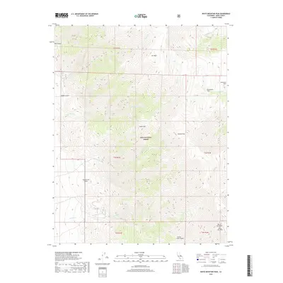
2018 Map of White Mountain Peak
USGS Topo · Published 2018About this map
Inyo National Forest dominates this high-altitude section of the White Inyo Range in Mono County, where the landscape is defined by extreme verticality and remote canyons. The terrain is anchored by several prominent summits including Mt Hogue, Indian Peak, and Headley Peak, leading south toward the high point of White Mtn Peak. A network of drainage systems such as Cottonwood Canyon, Middle Canyon, and Falls Canyon cut through the western slopes, while the eastern reaches give way to the high plateau of Chiatovich Flats. The presence of Jeffrey Mine Canyon in the southern portion of the sheet provides a tangible link to the mineral prospecting history of the region. Significant perennial and seasonal water sources are documented throughout, including Pellisier Cr, Indian Cr, and Lone Tree Cr, which have historically dictated the patterns of movement and resource extraction in this alpine environment.
Find a feature on this map
23 named features on this map. Tap any name to fly to it.
Don’t see what you’re looking for? This feature index may not catch every label — zoom into the map to look around manually.
Map Details
Editions of this 2018 White Mountain Peak Map
This is the sole edition of this map. No revisions or reprints were ever made.
Other maps of this area

1917 · White Mountain
USGS Topo · 1:125,000

1947 · Mariposa
USGS Topo · 1:250,000

1948 · Mariposa
USGS Topo · 1:250,000

1957 · Mariposa
USGS Topo · 1:250,000

1962 · Benton
USGS Topo · 1:62,500

1962 · Mt. Barcroft
USGS Topo · 1:62,500

1962 · White Mtn. Peak
USGS Topo · 1:62,500

1963 · Mariposa
USGS Topo · 1:250,000

1963 · Davis Mountain
USGS Topo · 1:62,500
1987 · Juniper Mtn
USGS Topo · 1:24,000