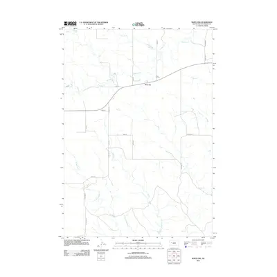
2012 Map of White Owl
USGS Topo · Published 2012About this map
White Owl serves as the central settlement on this Meade County landscape, where the prairie meets an intricate network of drainage systems. The town is situated near the White Owl Cem and White Owl Lake, which provides a distinct landmark in an area otherwise defined by the winding paths of White Owl Cr. The mapping of local county roads and section lines, such as Co Hwy MC-14B and Co Hwy MC-24, reflects the rural agricultural patterns of the region. A series of watercourses, including E Badlands Cr, W Badlands Cr, and Middle Badlands Cr, carve through the terrain to the south, while Pine Cr and W Tepee Cr draw the eye toward the east. This survey documents the persistent rural character of the South Dakota plains, centered on a small community and its surrounding ranchlands.
Find a feature on this map
25 named features on this map. Tap any name to fly to it.
Don’t see what you’re looking for? This feature index may not catch every label — zoom into the map to look around manually.
Map Details
Editions of this 2012 White Owl Map
This is the sole edition of this map. No revisions or reprints were ever made.
Other maps of this area

1953 · Rapid City
USGS Topo · 1:250,000

1954 · Dalzell NW
USGS Topo · 1:24,000

1954 · Dalzell NE
USGS Topo · 1:24,000

1954 · Boneita Springs
USGS Topo · 1:24,000

1957 · Rapid City
USGS Topo · 1:250,000

1959 · Enning
USGS Topo · 1:24,000

1959 · Redowl
USGS Topo · 1:24,000

1983 · Whiteman Owl NW
USGS Topo · 1:24,000

1983 · Whiteman Owl
USGS Topo · 1:24,000
1983 · Whiteman Owl SE
USGS Topo · 1:24,000