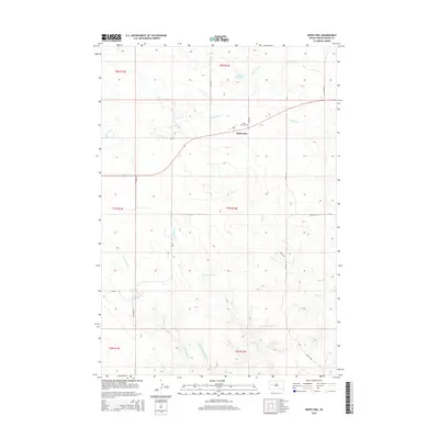
2015 Map of White Owl
USGS Topo · Published 2015About this map
The settlement of White Owl sits at the intersection of prairie roads in this 2015 study of Meade County, South Dakota. This small ranching community is defined by its proximity to White Owl Cr and the nearby White Owl Lake. The surrounding landscape is characterized by a complex network of intermittent drainages, including E Badlands Cr, Middle Badlands Cr, and W Badlands Cr, which carve through the plains. Local infrastructure is primarily composed of rural routes such as Howie Rd and Corral Rd, which connect isolated homesteads and ranch lands across the township divisions. The presence of the White Owl Cem north of the main road provides a historical anchor for family researchers, marking the long-term residence of those who managed these grazing lands in a region where water sources like Pine Cr and W Tepee Cr dictated the patterns of human settlement and agricultural survival.
Find a feature on this map
26 named features on this map. Tap any name to fly to it.
Don’t see what you’re looking for? This feature index may not catch every label — zoom into the map to look around manually.
Map Details
Editions of this 2015 White Owl Map
This is the sole edition of this map. No revisions or reprints were ever made.
Other maps of this area

1953 · Rapid City
USGS Topo · 1:250,000

1954 · Dalzell NW
USGS Topo · 1:24,000

1954 · Dalzell NE
USGS Topo · 1:24,000

1954 · Boneita Springs
USGS Topo · 1:24,000

1957 · Rapid City
USGS Topo · 1:250,000

1959 · Enning
USGS Topo · 1:24,000

1959 · Redowl
USGS Topo · 1:24,000

1983 · Whiteman Owl NW
USGS Topo · 1:24,000

1983 · Whiteman Owl
USGS Topo · 1:24,000
1983 · Whiteman Owl SE
USGS Topo · 1:24,000