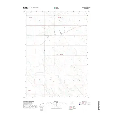
2017 Map of White Owl
USGS Topo · Published 2017About this map
White Owl serves as the primary focal point of this Meade County landscape, where the prairie topography is defined by an intricate network of drainage systems. The settlement is situated near the White Owl Cem and the waters of White Owl Lake, which feeds into White Owl Cr. The surrounding terrain transitions into the distinct geological features of the South Dakota badlands, evidenced by the converging paths of E Badlands Cr, Middle Badlands Cr, and W Badlands Cr. Transport through this rural expanse relies on a grid of section-line roads such as Howie Rd and Lang Rd, alongside the more diagonal route of Co Hwy 37 S. This 2017 survey illustrates the persistent ranching character of the region, where family-named landmarks like Ranch Rd and Tidewater Rd connect scattered homesteads across the townships.
Find a feature on this map
25 named features on this map. Tap any name to fly to it.
Don’t see what you’re looking for? This feature index may not catch every label — zoom into the map to look around manually.
Map Details
Editions of this 2017 White Owl Map
This is the sole edition of this map. No revisions or reprints were ever made.
Other maps of this area

1953 · Rapid City
USGS Topo · 1:250,000

1954 · Dalzell NW
USGS Topo · 1:24,000

1954 · Dalzell NE
USGS Topo · 1:24,000

1954 · Boneita Springs
USGS Topo · 1:24,000

1957 · Rapid City
USGS Topo · 1:250,000

1959 · Enning
USGS Topo · 1:24,000

1959 · Redowl
USGS Topo · 1:24,000

1983 · Whiteman Owl NW
USGS Topo · 1:24,000

1983 · Whiteman Owl
USGS Topo · 1:24,000
1983 · Whiteman Owl SE
USGS Topo · 1:24,000