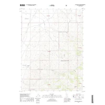
2018 Map of White Rock Canyon
USGS Topo · Published 2018About this map
Santa Rosa Range peaks dominate the eastern skyline of this high-desert landscape in Humboldt County, where the mountains drop away into the broad Quinn River Valley to the northwest. The terrain is defined by a series of dramatic drainages including White Rock Canyon and the winding Willow Creek, which is fed by the S Fork Willow Cr. Much of the southern and eastern portion of the map falls within the Humboldt National Forest, protecting the headwaters of Eagle Cr and Skull Cr. A network of utility and forest roads, such as Flat Creek Rd and Upper Willow Creek Rd, provides access to these elevations from the lowlands of Old Hwy 95. This 2018 survey reveals the persistent reliance on natural springs and seasonal creek beds for navigating this arid corner of Nevada.
Find a feature on this map
29 named features on this map. Tap any name to fly to it.
Don’t see what you’re looking for? This feature index may not catch every label — zoom into the map to look around manually.
Map Details
Editions of this 2018 White Rock Canyon Map
This is the sole edition of this map. No revisions or reprints were ever made.
Other maps of this area

1882 · Paradise
USGS Topo · 1:250,000

1893 · Paradise
USGS Topo · 1:250,000

1955 · McDermitt
USGS Topo · 1:250,000

1959 · McDermitt
USGS Topo · 1:250,000

1959 · Orovada
USGS Topo · 1:62,500

1959 · McDermitt
USGS Topo · 1:62,500

1959 · Hinkey Summit
USGS Topo · 1:62,500

1959 · Jordan Meadow
USGS Topo · 1:62,500

1985 · Quinn River Valley
USGS Topo · 1:100,000
1991 · Hoppin Peaks
USGS Topo · 1:24,000