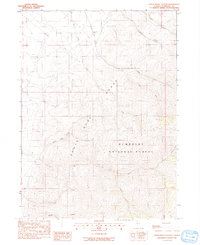
1991 Map of White Rock Canyon
USGS Topo · Published 1991About this map
The Santa Rosa Range dominates this portion of the Humboldt National Forest, where the high desert terrain is defined by a network of drainage systems including Willow Creek and Flat Creek. This 1991 provisional map, based on aerial photography from the mid-1980s, reveals a landscape primarily managed for resource extraction and ranching. Multiple labels for Prospects are scattered across the slopes, particularly near the South Fork Flat Creek and the headwaters of White Rock Canyon, indicating mineral exploration typical of the Nevada backcountry. The presence of Flat Creek Ranch in the northern reach provides a rare point of established habitation in an otherwise uninhabited wilderness of canyons and high peaks like those found along Skull Creek.
Find a feature on this map
18 named features on this map. Tap any name to fly to it.
Don’t see what you’re looking for? This feature index may not catch every label — zoom into the map to look around manually.
Map Details
Editions of this 1991 White Rock Canyon Map
This is the sole edition of this map. No revisions or reprints were ever made.
Other maps of this area

1882 · Paradise
USGS Topo · 1:250,000

1893 · Paradise
USGS Topo · 1:250,000

1955 · McDermitt
USGS Topo · 1:250,000

1959 · McDermitt
USGS Topo · 1:250,000

1959 · Orovada
USGS Topo · 1:62,500

1959 · McDermitt
USGS Topo · 1:62,500

1959 · Hinkey Summit
USGS Topo · 1:62,500

1959 · Jordan Meadow
USGS Topo · 1:62,500

1985 · Quinn River Valley
USGS Topo · 1:100,000
1991 · Hoppin Peaks
USGS Topo · 1:24,000