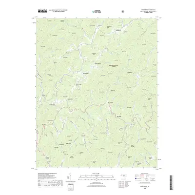
2019 Map of White Rock
USGS Topo · Published 2019About this map
Pisgah National Forest encompasses the high ridges of Madison County in this 2019 survey, where the deep drainages of Shelton Laurel Creek and Big Laurel Creek define the rugged topography. The landscape is dotted with small, historically isolated communities such as White Rock, Spillcorn, and Belva, often situated near the confluence of mountain branches. Genealogists will find a significant distribution of family burial grounds, including the Shelton Cemetery, Belva Cemetery, and Bullman Cemetery, which are scattered throughout the coves. The map reflects a mountain economy and settlement pattern tied to the terrain, with names like Rice Mill and Lumptown marking the lower elevations. High peaks such as Angelico Knob and Sugarloaf Mtn tower over the network of winding roads like Revere Road and Sodom Road, which follow the natural contours of the Appalachians.
Find a feature on this map
141 named features on this map. Tap any name to fly to it.
Don’t see what you’re looking for? This feature index may not catch every label — zoom into the map to look around manually.
Map Details
Editions of this 2019 White Rock Map
This is the sole edition of this map. No revisions or reprints were ever made.
Other maps of this area

1892 · Greeneville
USGS Topo · 1:125,000

1894 · Asheville
USGS Topo · 1:125,000

1896 · Greeneville
USGS Topo · 1:125,000

1901 · Asheville
USGS Topo · 1:125,000

1904 · Greeneville
USGS Topo · 1:125,000

1935 · Hot Springs
USGS Topo · 1:24,000

1935 · Spring Creek
USGS Topo · 1:24,000

1936 · Marshall
USGS Topo · 1:24,000

1936 · Greystone
USGS Topo · 1:24,000

1936 · Sams Gap
USGS Topo · 1:24,000