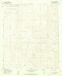
1955 Map of White Sands SE
USGS Topo · Published 1962About this map
Tularosa Valley defines this mid-century landscape, a high-desert floor dominated by the expanding defense operations of the Cold War era. The map reveals the intersection of the Fort Bliss Military Reservation and the White Sands Proving Ground, where the Military Reservation Boundary cuts across the arid basin. Historically significant details include a lone Telephone line threading through the scrub and isolated Ruins in the southeastern quadrant, hinting at the ranching or homesteading history that preceded the land's transition to military control. Surveyed during the mid-1950s by the Army Map Service, the topography illustrates a basin characterized by subtle elevation shifts and sparse markers of human occupation beyond the massive federal holdings.
Find a feature on this map
7 named features on this map. Tap any name to fly to it.
Don’t see what you’re looking for? This feature index may not catch every label — zoom into the map to look around manually.
Map Details
Editions of this 1955 White Sands SE Map
Other maps of this area

1940 · Orogrande
USGS Topo · 1:62,500

1940 · Newman
USGS Topo · 1:62,500

1941 · Desert
USGS Topo · 1:62,500

1943 · Parker Lake
USGS Topo · 1:62,500

1943 · Desert
USGS Topo · 1:62,500

1943 · Newman
USGS Topo · 1:62,500

1943 · Orogrande
USGS Topo · 1:62,500

1948 · Davies Tank
USGS Topo · 1:24,000

1948 · El Wood
USGS Topo · 1:24,000

1948 · Newman NW
USGS Topo · 1:24,000