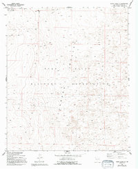
1955 Map of White Sands SE
USGS Topo · Published 1994About this map
Tularosa Valley defines the arid character of this desert landscape, where the vast extent of federal landholdings dominates the local geography. This survey, based on 1955 photography and updated in the mid-1990s, centers on the intersection of the Fort Bliss Military Reservation and the White Sands Missile Range Mil Res Bdy. The terrain is marked by sparse infrastructure, including a legacy Telephone line and a Trans Line that traverse the basin floor. Isolated Ruins provide a rare glimpse of earlier habitation or former military activity in a region otherwise characterized by natural landforms and military boundaries. The map illustrates the specialized land use of the Cold War era, where vast stretches of New Mexico were dedicated to aerospace and military testing.
Find a feature on this map
11 named features on this map. Tap any name to fly to it.
Don’t see what you’re looking for? This feature index may not catch every label — zoom into the map to look around manually.
Map Details
Editions of this 1955 White Sands SE Map
Other maps of this area

1940 · Orogrande
USGS Topo · 1:62,500

1940 · Newman
USGS Topo · 1:62,500

1941 · Desert
USGS Topo · 1:62,500

1943 · Parker Lake
USGS Topo · 1:62,500

1943 · Desert
USGS Topo · 1:62,500

1943 · Newman
USGS Topo · 1:62,500

1943 · Orogrande
USGS Topo · 1:62,500

1948 · Davies Tank
USGS Topo · 1:24,000

1948 · El Wood
USGS Topo · 1:24,000

1948 · Newman NW
USGS Topo · 1:24,000