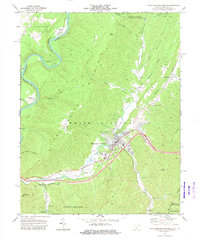
1972 Map of White Sulphur Springs
USGS Topo · Published 1975About this map
White Sulphur Springs serves as the focal point of this early 1970s survey, where the Chesapeake and Ohio railroad corridor follows the winding path of Howard Creek. The town is surrounded by a mix of leisure and industry, featuring several Golf Courses and a Fish Hatchery alongside established neighborhoods. To the north, the terrain rises sharply into Bobs Ridge and Coles Mountain, while the Greenbrier River carves a dramatic loop near Loopemount in the west. This landscape reflects the dual character of the region as both a resort destination and a rugged mountain corridor. Rural life is anchored by small community landmarks like Eckle Ch, Oakhurst Ch, and Greenbrier Valley Ch, while the southern expanse is dominated by the protected timberlands of Greenbrier State Forest.
Find a feature on this map
48 named features on this map. Tap any name to fly to it.
Don’t see what you’re looking for? This feature index may not catch every label — zoom into the map to look around manually.
Map Details
Editions of this 1972 White Sulphur Springs Map
2 editions found
Other maps of this area

1887 · Lewisburg
USGS Topo · 1:125,000

1891 · Lewisburg
USGS Topo · 1:125,000

1921 · Callaghan
USGS Topo · 1:48,000

1921 · White Sulphur Springs
USGS Topo · 1:48,000

1921 · Ronceverte
USGS Topo · 1:48,000

1923 · White Sulphur Springs
USGS Topo · 1:62,500

1923 · Ronceverte
USGS Topo · 1:62,500

1923 · Callaghan
USGS Topo · 1:62,500

1935 · White Sulphur Springs
USGS Topo · 1:62,500

1939 · White Sulphur Springs
USGS Topo · 1:62,500