
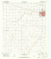
1971 Map of Whiteface NW
USGS Topo · Published 1973About this map
Morton sits on the western edge of this High Plains landscape, serving as a hub for the surrounding agricultural and industrial activity of Cochran County. The map captures a transition from the structured street grid of the town to a vast expanse punctuated by the Levelland and Slaughter Oil and Gas Field, indicating the area's heavy reliance on petroleum extraction. Local social and civic life is anchored by landmarks like St Ann Church, the Morton Country Club, and the Rodeo Ground. The terrain is characterized by subtle elevation changes such as Ramsey Hill and various depressions, while the infrastructure of the County Airport and a scattering of water tanks and wells highlights the logistical needs of this semi-arid region during the early 1970s.
Find a feature on this map
11 named features on this map. Tap any name to fly to it.
Don’t see what you’re looking for? This feature index may not catch every label — zoom into the map to look around manually.
Map Details
Editions of this 1971 Whiteface NW Map
This is the sole edition of this map. No revisions or reprints were ever made.
Other maps of this area

1954 · Brownfield
USGS Topo · 1:250,000

1958 · Brownfield
USGS Topo · 1:250,000

1962 · Brownfield
USGS Topo · 1:250,000

1964 · Pep
USGS Topo · 1:24,000

1965 · Pettit
USGS Topo · 1:24,000

1965 · Whiteface
USGS Topo · 1:24,000

1969 · Enochs
USGS Topo · 1:24,000

1969 · Lehman
USGS Topo · 1:24,000

1970 · Whiteface SW
USGS Topo · 1:24,000
1971 · Morton
USGS Topo · 1:24,000