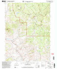
2000 Map of Whiteley Peak
USGS Topo · Published 2004About this map
Muddy Creek winds through the high country of Grand County, defining a valley where ranching outposts like the Haworth Ranch and Ritschard Ranch established a presence near the Muddy Valley Sch. This landscape is dominated by the Rabbit Ears Range and the Continental Divide, which separates the Routt and Arapaho national forests. The terrain is marked by distinctive geological features such as Grannys Nipple, Grannys Nightcap, and the prominent Whiteley Peak. High-altitude water sources including the Ryder Lakes and Parsons Reservoir serve the drainages of Lindsey Creek and Antelope Creek. The presence of several family-named ranches and a rural schoolhouse along the creek bottom illustrates the persistent, though sparse, human footprint within this high-elevation wilderness at the turn of the 21st century.
Find a feature on this map
37 named features on this map. Tap any name to fly to it.
Don’t see what you’re looking for? This feature index may not catch every label — zoom into the map to look around manually.
Map Details
Editions of this 2000 Whiteley Peak Map
This is the sole edition of this map. No revisions or reprints were ever made.
Other maps of this area

1954 · Craig
USGS Topo · 1:250,000

1956 · Rabbit Ears Peak
USGS Topo · 1:24,000

1956 · Lake Agnes
USGS Topo · 1:24,000

1956 · Kremmling
USGS Topo · 1:62,500

1956 · Spicer Peak
USGS Topo · 1:24,000

1956 · Buffalo Peak
USGS Topo · 1:24,000

1956 · Whiteley Peak
USGS Topo · 1:24,000

1956 · Hyannis Peak
USGS Topo · 1:24,000

1956 · Gore Pass
USGS Topo · 1:62,500

1956 · Hyannis Peak
USGS Topo · 1:62,500