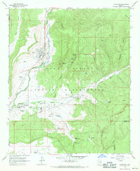
1967 Map of Whiteriver
USGS Topo · Published 1971About this map
Whiteriver serves as the focal point of this mid-century survey, situated at the confluence where the North Fork White River meets the East Fork White River. The landscape is defined by the extensive boundaries of the Fort Apache Military Reservation, which encompasses a complex network of administrative and educational facilities. Significant local institutions include the Theodore Roosevelt Indian Sch and the East Fork Mission, reflecting the area's institutional history. To the south, the settlement of Fort Apache is clearly delineated alongside its Military Cem. The geography transitions from the river valleys to the prominent Sevenmile Rim and Big A Mountain, with numerous water tanks like Upper Sevenmile Tank and Lime Spring Tank supporting the region's ranching or wildlife needs. This map provides a clear record of the indigenous community and federal presence in the White Mountains before subsequent decades of development.
Find a feature on this map
61 named features on this map. Tap any name to fly to it.
Don’t see what you’re looking for? This feature index may not catch every label — zoom into the map to look around manually.
Map Details
Editions of this 1967 Whiteriver Map
This is the sole edition of this map. No revisions or reprints were ever made.
Other maps of this area

1954 · Clifton
USGS Topo · 1:250,000

1954 · Mesa
USGS Topo · 1:250,000

1957 · Mesa
USGS Topo · 1:250,000

1957 · Clifton
USGS Topo · 1:250,000

1958 · Clifton
USGS Topo · 1:250,000

1958 · Mesa
USGS Topo · 1:250,000

1960 · Mesa
USGS Topo · 1:250,000

1962 · Clifton
USGS Topo · 1:250,000

1964 · Mesa
USGS Topo · 1:250,000
1966 · Round Top Mtn
USGS Topo · 1:24,000