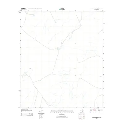
2013 Map of Whiterock Hills
USGS Topo · Published 2013About this map
The Whiterock Hills define the western landscape of this Hudspeth County quadrangle, where the arid terrain is punctuated by a network of essential water catchment sites. In this corner of West Texas, the presence of these earthen tanks illustrates the fundamental reliance on managed water sources for ranching and livestock. Key drainage points are marked by features such as Whiterock Tank, Silva Tank, and Cunningham Tank, which serve as vital infrastructure for the surrounding territory. The map reveals a sparse network of local roads and 4WD tracks that navigate the dry washes and hills, connecting remote locations like Little Borrego Tank and Red Rock Tank. This record of the early 21st-century landscape highlights the persistent character of the Trans-Pecos region, where man-made improvements like Level Tank and Little Cunningham Tank are the primary landmarks across the desert floor.
Find a feature on this map
8 named features on this map. Tap any name to fly to it.
Don’t see what you’re looking for? This feature index may not catch every label — zoom into the map to look around manually.
Map Details
Editions of this 2013 Whiterock Hills Map
This is the sole edition of this map. No revisions or reprints were ever made.
Other maps of this area

1894 · Fort Hancock
USGS Topo · 1:125,000

1903 · Cerro Alto
USGS Topo · 1:125,000

1942 · Borrego
USGS Topo · 1:62,500

1943 · Tepee Butte
USGS Topo · 1:62,500

1943 · Finlay Mountains
USGS Topo · 1:62,500

1943 · Fort Hancock
USGS Topo · 1:62,500

1954 · Van Horn
USGS Topo · 1:250,000

1958 · Van Horn
USGS Topo · 1:250,000
1972 · Fort Hancock NW
USGS Topo · 1:24,000
1972 · Cavett Lake
USGS Topo · 1:24,000