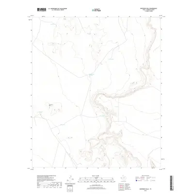
2019 Map of Whiterock Hills
USGS Topo · Published 2019About this map
Whiterock Hills rise from the high desert floor of Hudspeth County, characterizing a landscape defined by its arid hydrology and livestock history. This 2019 survey documents a network of man-made water catchments, including Silva Tank and Whiterock Tank, which are essential for managing water in this section of West Texas. The distribution of these features, such as Cunningham Tank and Little Cunningham Tank, suggests a region organized for ranching operations where every depression or basin is utilized for catchment. The contour data reveals the complex drainage patterns and isolated elevations that dictate movement and land use across this corner of the state.
Find a feature on this map
8 named features on this map. Tap any name to fly to it.
Don’t see what you’re looking for? This feature index may not catch every label — zoom into the map to look around manually.
Map Details
Editions of this 2019 Whiterock Hills Map
This is the sole edition of this map. No revisions or reprints were ever made.
Other maps of this area

1894 · Fort Hancock
USGS Topo · 1:125,000

1903 · Cerro Alto
USGS Topo · 1:125,000

1942 · Borrego
USGS Topo · 1:62,500

1943 · Tepee Butte
USGS Topo · 1:62,500

1943 · Finlay Mountains
USGS Topo · 1:62,500

1943 · Fort Hancock
USGS Topo · 1:62,500

1954 · Van Horn
USGS Topo · 1:250,000

1958 · Van Horn
USGS Topo · 1:250,000
1972 · Fort Hancock NW
USGS Topo · 1:24,000
1972 · Cavett Lake
USGS Topo · 1:24,000