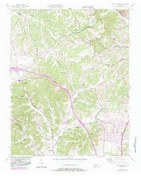
1955 Map of Whites Creek
USGS Topo · Published 1983About this map
Paradise Ridge and Dividing Ridge form the elevated backbone of this mid-century landscape north of Nashville, where the Robertson Co and Davidson County Metropolitan Government lines meet. The terrain is defined by a dense network of hollows such as Trantham Hollow, Bennett Hollow, and Kaufman Hollow, which feed into Whites Creek and the South Fork Sycamore Creek. Community life centers on crossroads settlements and rural congregations, including Spring Hill Ch, Walkers Ch, and the Alex Green Sch.
Find a feature on this map
47 named features on this map. Tap any name to fly to it.
Don’t see what you’re looking for? This feature index may not catch every label — zoom into the map to look around manually.
Map Details
Editions of this 1955 Whites Creek Map
4 editions found

Other maps of this area

1903 · Nashville
USGS Topo · 1:125,000

1931 · Ridgetop
USGS Topo · 1:62,500

1932 · Hermitage
USGS Topo · 1:62,500

1932 · Nashville
USGS Topo · 1:62,500

1935 · Ridgetop
USGS Topo · 1:62,500

1942 · Gallatin
USGS Topo · 1:100,000

1942 · Lebanon
USGS Topo · 1:100,000

1952 · Goodlettsville
USGS Topo · 1:24,000

1952 · Nashville West
USGS Topo · 1:24,000

1952 · Nashville East
USGS Topo · 1:24,000