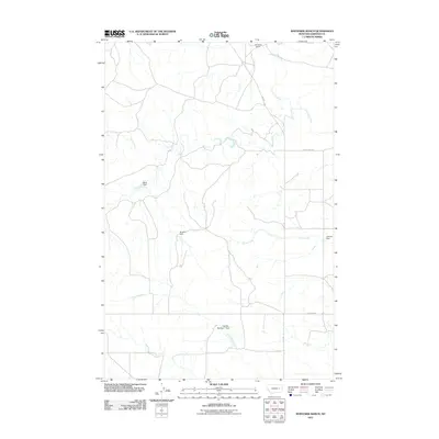
2011 Map of Whiteside Ranch
USGS Topo · Published 2011About this map
Whiteside Ranch anchors this high-plains landscape in Garfield County, where the network of drainage and water management defines the local geography. The map documents a complex system of seasonal waterways and earthen improvements, including named water control points such as Bank Dam, Ol John Dam, and Steffins Number 1 Dam. These features illustrate the essential ranching infrastructure required to manage water in an arid environment where Antelope Creek and Little Dry Creek meander across the terrain.
Find a feature on this map
12 named features on this map. Tap any name to fly to it.
Don’t see what you’re looking for? This feature index may not catch every label — zoom into the map to look around manually.
Map Details
Editions of this 2011 Whiteside Ranch Map
This is the sole edition of this map. No revisions or reprints were ever made.
Other maps of this area

1954 · Jordan
USGS Topo · 1:250,000

1956 · Jordan
USGS Topo · 1:250,000

1958 · Jordan
USGS Topo · 1:250,000

1964 · Jordan
USGS Topo · 1:250,000

1965 · Whiteside Ranch
USGS Topo · 1:24,000

1965 · Calamity Coulee
USGS Topo · 1:24,000
1965 · Tree Coulee School
USGS Topo · 1:24,000

1965 · Hedstrom Lake NW
USGS Topo · 1:24,000

1965 · Hafla School
USGS Topo · 1:24,000
1965 · Sleepy Hollow
USGS Topo · 1:24,000