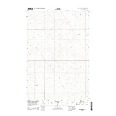
2014 Map of Whiteside Ranch
USGS Topo · Published 2014About this map
Whiteside Ranch sits at the center of this 2014 geographic study of Garfield County, Montana, where a network of ephemeral watercourses and unpaved routes define the high plains. The landscape is drained by Little Dry Cr, Taylor Cr, and Jones Cr, showing a pattern of natural drainage that dictates the layout of regional cattle operations. In the southern portion of the sheet, Antelope Cr meanders near Two Furrow Rd and E Two Furrow Rd. These primitive roadways are critical markers for local history and land use, illustrating how ranchers navigate the vast public land survey sections. This map serves as a contemporary record of the enduring agricultural and ranching infrastructure that has shaped this part of the American West for generations.
Find a feature on this map
11 named features on this map. Tap any name to fly to it.
Don’t see what you’re looking for? This feature index may not catch every label — zoom into the map to look around manually.
Map Details
Editions of this 2014 Whiteside Ranch Map
This is the sole edition of this map. No revisions or reprints were ever made.
Other maps of this area

1954 · Jordan
USGS Topo · 1:250,000

1956 · Jordan
USGS Topo · 1:250,000

1958 · Jordan
USGS Topo · 1:250,000

1964 · Jordan
USGS Topo · 1:250,000

1965 · Whiteside Ranch
USGS Topo · 1:24,000

1965 · Calamity Coulee
USGS Topo · 1:24,000
1965 · Tree Coulee School
USGS Topo · 1:24,000

1965 · Hedstrom Lake NW
USGS Topo · 1:24,000

1965 · Hafla School
USGS Topo · 1:24,000
1965 · Sleepy Hollow
USGS Topo · 1:24,000