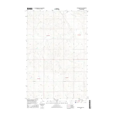
2017 Map of Whiteside Ranch
USGS Topo · Published 2017About this map
Whiteside Ranch serves as a lone namesake landmark in this remote corner of Garfield County, marking a site of long-standing ranching tradition in the eastern Montana plains. This 2017 survey by the U.S. Geological Survey illustrates a landscape defined by seasonal watercourses and drainage patterns, most notably the winding path of Little Dry Cr as it traverses the northern sections. The map reveals the intricate network of coulees and ridges that characterize this high-plains terrain, providing a contemporary perspective on land use and remote habitation in a region where settlement is measured in miles between neighbors. Researchers and land managers can trace the current infrastructure of rural life, from access roads to the subtle topography that dictates the movement of water and livestock across this vast range.
Find a feature on this map
2 named features on this map. Tap any name to fly to it.
Don’t see what you’re looking for? This feature index may not catch every label — zoom into the map to look around manually.
Map Details
Editions of this 2017 Whiteside Ranch Map
This is the sole edition of this map. No revisions or reprints were ever made.
Other maps of this area

1954 · Jordan
USGS Topo · 1:250,000

1956 · Jordan
USGS Topo · 1:250,000

1958 · Jordan
USGS Topo · 1:250,000

1964 · Jordan
USGS Topo · 1:250,000

1965 · Whiteside Ranch
USGS Topo · 1:24,000

1965 · Calamity Coulee
USGS Topo · 1:24,000
1965 · Tree Coulee School
USGS Topo · 1:24,000

1965 · Hedstrom Lake NW
USGS Topo · 1:24,000

1965 · Hafla School
USGS Topo · 1:24,000
1965 · Sleepy Hollow
USGS Topo · 1:24,000