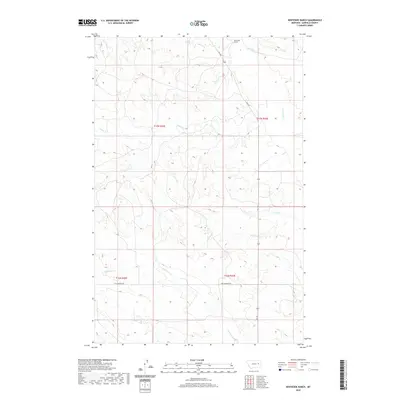
2020 Map of Whiteside Ranch
USGS Topo · Published 2020About this map
Whiteside Ranch anchors the northern reaches of this Garfield County landscape, where the high plains are carved by a network of drainage channels. The terrain is defined by the winding paths of Little Dry Cr and Jones Cr, which cut through the open rangeland. In the southern portion of the quadrangle, Antelope Cr meanders across a landscape marked by the transition between township grids, including t17n r42e and t16n r43e. Transportation in this isolated area is limited to rugged tracks and rural routes like Uall Rd and the descriptive Two Furrows Rd. This survey captures the sparse settlement and hydraulic patterns of the Montana prairie as they appeared in the early 21st century.
Find a feature on this map
10 named features on this map. Tap any name to fly to it.
Don’t see what you’re looking for? This feature index may not catch every label — zoom into the map to look around manually.
Map Details
Editions of this 2020 Whiteside Ranch Map
This is the sole edition of this map. No revisions or reprints were ever made.
Other maps of this area

1954 · Jordan
USGS Topo · 1:250,000

1956 · Jordan
USGS Topo · 1:250,000

1958 · Jordan
USGS Topo · 1:250,000

1964 · Jordan
USGS Topo · 1:250,000

1965 · Whiteside Ranch
USGS Topo · 1:24,000

1965 · Calamity Coulee
USGS Topo · 1:24,000
1965 · Tree Coulee School
USGS Topo · 1:24,000

1965 · Hedstrom Lake NW
USGS Topo · 1:24,000

1965 · Hafla School
USGS Topo · 1:24,000
1965 · Sleepy Hollow
USGS Topo · 1:24,000