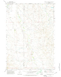
1971 Map of Whitetail Creek SE
USGS Topo · Published 1974About this map
The high plains of the Campbell and Weston County line are defined here by a landscape of drainage draws and scattered energy exploration. This early 1970s survey illustrates a region where ranching and resource extraction coexist, with isolated family holdings like the Pickrel Ranch, Dillinger Ranch, and Bowden Ranch established near the seasonal watercourses of Four Horse Creek and Raven Creek. The prevalence of numerous Drill Holes and Oil Wells across the northeastern sections signals the intensifying industrial footprint of the Powder River Basin's energy sector during this era. Topographic detail captures the intricate erosion patterns of Mexican Draw and the headwaters of the Fourche, providing a clear view of the terrain before later decades of further development.
Find a feature on this map
13 named features on this map. Tap any name to fly to it.
Don’t see what you’re looking for? This feature index may not catch every label — zoom into the map to look around manually.
Map Details
Editions of this 1971 Whitetail Creek SE Map
This is the sole edition of this map. No revisions or reprints were ever made.
Other maps of this area

1918 · Moorcroft
USGS Topo · 1:125,000

1954 · Gillette
USGS Topo · 1:250,000

1955 · Newcastle
USGS Topo · 1:250,000

1955 · Gillette
USGS Topo · 1:250,000

1958 · Gillette
USGS Topo · 1:250,000

1958 · Newcastle
USGS Topo · 1:250,000

1962 · Gillette
USGS Topo · 1:250,000

1971 · Coon Track Creek
USGS Topo · 1:24,000

1971 · Whitetail Creek
USGS Topo · 1:24,000

1971 · Rough Creek
USGS Topo · 1:24,000