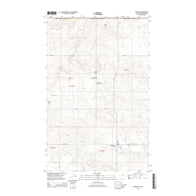
2014 Map of Whitetail
USGS Topo · Published 2014About this map
Whitetail sits near the international boundary in Daniels County, serving as a remote outpost in Montana’s high plains. The town site is structured around a small street grid including Main St and Limon St, bordered to the south by the waters of Whitetail Cr and the Whitetail Reservoir. This 2014 survey documents the agricultural and drainage patterns of the region, where the terrain is defined by a network of seasonal watercourses known as coulees. Notable drainages include Outlaw Coulee and Loomis Coulee, which carve through the plains toward the Canadian border. Landmark elevations like Square Butte and Long Butte provide orientation points in a landscape primarily utilized for ranching and dryland farming. Local history is anchored at the Whitetail Cem east of the main settlement, while the surrounding road network, including Radar Rd and Rubin Butte Rd, reflects the expansive scale of rural land management.
Find a feature on this map
30 named features on this map. Tap any name to fly to it.
Don’t see what you’re looking for? This feature index may not catch every label — zoom into the map to look around manually.
Map Details
Editions of this 2014 Whitetail Map
This is the sole edition of this map. No revisions or reprints were ever made.
Other maps of this area

1954 · Wolf Point
USGS Topo · 1:250,000

1958 · Wolf Point
USGS Topo · 1:250,000

1973 · Madoc
USGS Topo · 1:24,000

1973 · Flaxville
USGS Topo · 1:24,000

1973 · Whitetail
USGS Topo · 1:24,000

1973 · Navajo
USGS Topo · 1:24,000

1973 · Goodale Coulee
USGS Topo · 1:24,000

1973 · Si Merrell Slough
USGS Topo · 1:24,000

1983 · Scobey
USGS Topo · 1:100,000
2011 · Si Merrell Slough
USGS Topo · 1:24,000