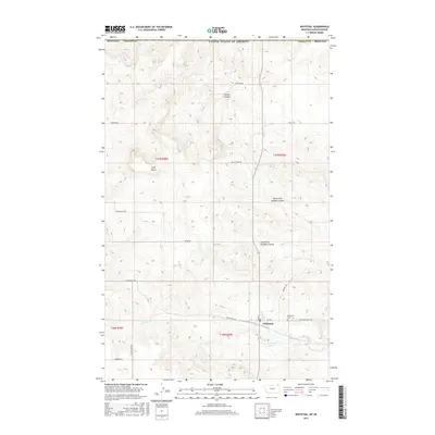
2017 Map of Whitetail
USGS Topo · Published 2017About this map
Whitetail sits near the international boundary in Daniels County, serving as a focal point for this high plains landscape at the edge of the United States of America. The settlement is defined by a traditional grid of streets including Main St and 1st Ave, while the surrounding rural geography is marked by deep drainage patterns such as Outlaw Coulee, North Fork Goodale Coulee, and South Fork Goodale Coulee. Prominent terrain features like Long Butte break the horizon, providing vertical relief in an area primarily dedicated to agriculture and ranching. Water management is evident near the townsite, where the Whitetail Cr feeds into the Whitetail Reservoir. Local history is anchored by the Whitetail Cem and a network of gravel section-line roads, such as Overland Rd and Ray Lacombe Rd, which reflect the enduring land-use patterns of northeastern Montana.
Find a feature on this map
28 named features on this map. Tap any name to fly to it.
Don’t see what you’re looking for? This feature index may not catch every label — zoom into the map to look around manually.
Map Details
Editions of this 2017 Whitetail Map
This is the sole edition of this map. No revisions or reprints were ever made.
Other maps of this area

1954 · Wolf Point
USGS Topo · 1:250,000

1958 · Wolf Point
USGS Topo · 1:250,000

1973 · Madoc
USGS Topo · 1:24,000

1973 · Flaxville
USGS Topo · 1:24,000

1973 · Whitetail
USGS Topo · 1:24,000

1973 · Navajo
USGS Topo · 1:24,000

1973 · Goodale Coulee
USGS Topo · 1:24,000

1973 · Si Merrell Slough
USGS Topo · 1:24,000

1983 · Scobey
USGS Topo · 1:100,000
2011 · Si Merrell Slough
USGS Topo · 1:24,000