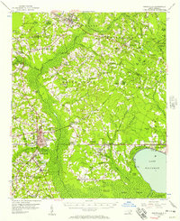
1955 Map of Whiteville
USGS Topo · Published 1957About this map
Whiteville serves as the focal point of this mid-century survey, situated at the junction of the Atlantic Coast Line and the extensive marshlands of the Carolina coastal plain. The landscape is defined by its complex hydrology, where the Waccamaw River Swamp and Abbotts Swamp create a network of wetlands surrounding the deep waters of Lake Waccamaw. This era shows a rural economy deeply integrated with its geography, evidenced by features like the Richardson Millpond and Clark Millpond.
Find a feature on this map
94 named features on this map. Tap any name to fly to it.
Don’t see what you’re looking for? This feature index may not catch every label — zoom into the map to look around manually.
Map Details
Editions of this 1955 Whiteville Map
2 editions found
Other maps of this area

1942 · Juniper Creek
USGS Topo · 1:24,000

1943 · Nakina
USGS Topo · 1:24,000

1953 · Chadbourn
USGS Topo · 1:62,500

1953 · Florence
USGS Topo · 1:250,000

1954 · Florence
USGS Topo · 1:250,000

1954 · White Lake
USGS Topo · 1:62,500

1954 · Bolton
USGS Topo · 1:62,500

1955 · Whiteville
USGS Topo · 1:62,500

1955 · Elizabethtown
USGS Topo · 1:62,500

1957 · Bladenboro
USGS Topo · 1:62,500