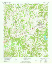
1959 Map of Whiteville
USGS Topo · Published 1973About this map
The town of Whiteville serves as the focal point for this West Tennessee landscape, where the Fayette Co Hardeman Co boundary line splits a region defined by agricultural heritage and small-town infrastructure. The Louisville And Nashville railroad corridor cuts diagonally across the terrain, passing through the settlement of Laconia and north toward Fayette Corners. This transportation artery is mirrored by a network of rural schoolhouses and churches that anchored the mid-century community, including the Smith No 3 Sch and Smyrna Ch.
Find a feature on this map
32 named features on this map. Tap any name to fly to it.
Don’t see what you’re looking for? This feature index may not catch every label — zoom into the map to look around manually.
Map Details
Editions of this 1959 Whiteville Map
3 editions found
Other maps of this area

1949 · Moscow
USGS Topo · 1:62,500

1950 · Middleburg
USGS Topo · 1:24,000

1951 · Middleburg
USGS Topo · 1:24,000

1951 · Hickory Valley
USGS Topo · 1:24,000

1952 · Dancyville
USGS Topo · 1:24,000

1952 · Laconia
USGS Topo · 1:24,000

1952 · Stanton
USGS Topo · 1:62,500

1956 · Blytheville
USGS Topo · 1:250,000

1959 · Blytheville
USGS Topo · 1:250,000

1959 · Whiteville
USGS Topo · 1:24,000