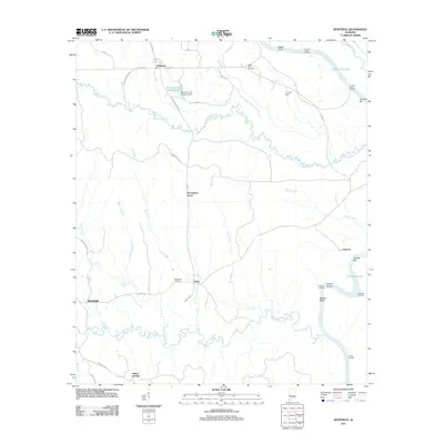
2011 Map of Whitfield
USGS Topo · Published 2011About this map
Tombigbee River frontage and the winding course of Coto h aga Creek dominate this 2011 survey of western Alabama. Small settlements like Whitfield, Edna, and Pelham are connected by a network of rural roads such as Boll Weevil Rd and Old Santee RR Rd, the latter hinting at the region's former rail history. The map captures an era of river-based infrastructure, evidenced by numerous historical river points including Crooms Upper Landing, Crooms Lower Landing, and Liberty Landing.
Find a feature on this map
50 named features on this map. Tap any name to fly to it.
Don’t see what you’re looking for? This feature index may not catch every label — zoom into the map to look around manually.
Map Details
Editions of this 2011 Whitfield Map
This is the sole edition of this map. No revisions or reprints were ever made.
Other maps of this area

1953 · Montgomery
USGS Topo · 1:250,000

1953 · Meridian
USGS Topo · 1:250,000

1956 · Montgomery
USGS Topo · 1:250,000

1957 · Meridian
USGS Topo · 1:250,000

1957 · Montgomery
USGS Topo · 1:250,000

1965 · Meridian
USGS Topo · 1:250,000

1970 · Myrtlewood North
USGS Topo · 1:24,000
1970 · Jefferson
USGS Topo · 1:24,000

1971 · Whitfield
USGS Topo · 1:24,000

1971 · Coatopa
USGS Topo · 1:24,000