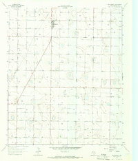
1964 Map of Whitharral
USGS Topo · Published 1968About this map
The agricultural landscape of the Texas High Plains centers on Whitharral in this mid-1960s study. The settlement's layout includes a localized concentration of civic and utility features, including an Athletic Field and a nearby Whitharral Cem. The surrounding territory is defined by a dense network of energy and water infrastructure, with numerous Wells and an Oil Well punctuating the grid-patterned fields.
Find a feature on this map
12 named features on this map. Tap any name to fly to it.
Don’t see what you’re looking for? This feature index may not catch every label — zoom into the map to look around manually.
Map Details
Editions of this 1964 Whitharral Map
This is the sole edition of this map. No revisions or reprints were ever made.
Other maps of this area
1954 · Brownfield
USGS Topo · 1:250,000
1957 · Anton
USGS Topo · 1:62,500
1957 · Wolfforth
USGS Topo · 1:62,500
1958 · Brownfield
USGS Topo · 1:250,000
1962 · Brownfield
USGS Topo · 1:250,000
1964 · Oklahoma Flat
USGS Topo · 1:24,000
1964 · Lums Chapel
USGS Topo · 1:24,000
1965 · Levelland West
USGS Topo · 1:24,000
1965 · Levelland East
USGS Topo · 1:24,000
1965 · Hester Ranch
USGS Topo · 1:24,000