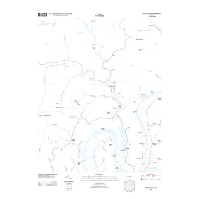
2013 Map of Whitleyville
USGS Topo · Published 2013About this map
Whitleyville and the surrounding Jackson County highlands appear here in the early 21st century, defined by the winding waters of the Cordell Hull Reservoir. The landscape is etched with numerous named hollows and ridges, reflecting a deeply localized geography where places like Drapers Hollow, Aunt Sal Hollow, and Happy Hollow retain their historical identities. The reservoir itself dominates the southern half of the sheet, creating a complex shoreline around Chimney Knob and the Cub Creek Shoals.
Find a feature on this map
109 named features on this map. Tap any name to fly to it.
Don’t see what you’re looking for? This feature index may not catch every label — zoom into the map to look around manually.
Map Details
Editions of this 2013 Whitleyville Map
This is the sole edition of this map. No revisions or reprints were ever made.
Other maps of this area

1925 · Gainesboro
USGS Topo · 1:62,500

1929 · Gainesboro
USGS Topo · 1:62,500

1929 · Tompkinsville
USGS Topo · 1:62,500

1931 · Red Boiling Springs
USGS Topo · 1:62,500

1932 · Carthage
USGS Topo · 1:62,500

1956 · Corbin
USGS Topo · 1:250,000

1958 · Corbin
USGS Topo · 1:250,000
1968 · Dodson Branch
USGS Topo · 1:24,000
1968 · Willette
USGS Topo · 1:24,000
1968 · Burristown
USGS Topo · 1:24,000