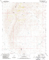
1986 Map of Whitlock Peak
USGS Topo · Published 1987About this map
Whitlock Peak stands as the primary landmark in this corner of the high desert, straddling the boundary line between Graham and Greenlee counties. The landscape is defined by a network of drainage features and water catchments vital for ranching and livestock in the arid Southwest. Named canyons like Stewart Canyon, Stocks Canyon, and Poppy Canyon carve through the terrain, leading toward the broad expanse of the Whitlock Valley. Human presence is marked by scattered water infrastructure, including Big Tank, Lost Lake, and various numbered tanks and wells that suggest a history of grazing management. To the southeast, the elevation rises again toward the Bobcat Hills and the prominent Round Mountain. This 1980s survey captures the region's topography before significant modern changes, preserving the locations of remote water sources and cattle-country landmarks like Old Camp Canyon and Sands Draw.
Find a feature on this map
19 named features on this map. Tap any name to fly to it.
Don’t see what you’re looking for? This feature index may not catch every label — zoom into the map to look around manually.
Map Details
Editions of this 1986 Whitlock Peak Map
This is the sole edition of this map. No revisions or reprints were ever made.
Other maps of this area

1917 · San Simon
USGS Topo · 1:125,000

1926 · Orange Butte
USGS Topo · 1:62,500

1928 · Bowie
USGS Topo · 1:62,500

1949 · Bowie
USGS Topo · 1:62,500

1950 · San Simon
USGS Topo · 1:62,500

1950 · Bowie
USGS Topo · 1:62,500

1951 · San Simon
USGS Topo · 1:62,500

1954 · Silver City
USGS Topo · 1:250,000

1958 · Silver City
USGS Topo · 1:250,000

1960 · Duncan
USGS Topo · 1:62,500