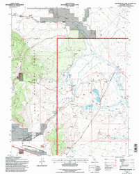
1994 Map of Whitmore Hot Sprs
USGS Topo · Published 1997About this map
Long Valley is defined by its thermal activity and hydrothermal features, as documented in this mid-1990s record. The landscape is dominated by the sprawling Alkali Flat and the saline waters of Big Alkali Lake and Little Alkali Lake, set against the backdrop of the Inyo National Forest. Human activity in this geothermal basin is concentrated near water sources, including the Hot Creek State Fish Hatchery and the clustered settlements at Whitmore Hot Sprs and Benton Crossing.
Find a feature on this map
38 named features on this map. Tap any name to fly to it.
Don’t see what you’re looking for? This feature index may not catch every label — zoom into the map to look around manually.
Map Details
Editions of this 1994 Whitmore Hot Sprs Map
This is the sole edition of this map. No revisions or reprints were ever made.
Other maps of this area

1914 · Mt. Morrison
USGS Topo · 1:125,000

1947 · Mariposa
USGS Topo · 1:250,000

1948 · Mariposa
USGS Topo · 1:250,000

1953 · Mt. Morrison
USGS Topo · 1:62,500

1953 · Casa Diablo Mtn
USGS Topo · 1:62,500

1957 · Mariposa
USGS Topo · 1:250,000

1962 · Cowtrack Mtn
USGS Topo · 1:62,500

1962 · Glass Mountain
USGS Topo · 1:62,500

1963 · Mariposa
USGS Topo · 1:250,000
1983 · Whitmore Hot Sprs
USGS Topo · 1:24,000