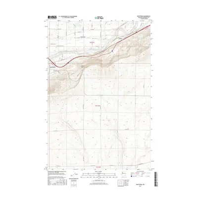
2017 Map of Whitstran
USGS Topo · Published 2017About this map
Prosser stands at the western edge of this landscape, where the Yakima River winds eastward toward the small settlements of Whitstran and Gibbon. This portion of Benton County is defined by its complex irrigation infrastructure, essential for the region's agricultural output. The Chandler Canal and the Prosser Lateral trace the contours above the river valley, facilitating the transformation of the arid terrain. To the south, the massive incline of the Horse Heaven Hills rises sharply, dominating the topography with steep coulees and ridges. The road network, including Wine Country Rd and the Inland Empire Hwy, follows the natural corridor created by the river, while smaller creeks like Spring Cr and Snipes Cr drain the northern uplands. This survey documents the intersection of natural river dynamics and human-engineered water management in a vital viticultural and farming district.
Find a feature on this map
50 named features on this map. Tap any name to fly to it.
Don’t see what you’re looking for? This feature index may not catch every label — zoom into the map to look around manually.
Map Details
Editions of this 2017 Whitstran Map
This is the sole edition of this map. No revisions or reprints were ever made.
Other maps of this area

1915 · Prosser
USGS Topo · 1:125,000

1917 · Prosser
USGS Topo · 1:125,000

1950 · Grandview
USGS Topo · 1:62,500

1951 · Grandview
USGS Topo · 1:62,500

1951 · Corral Canyon
USGS Topo · 1:62,500

1953 · Walla Walla
USGS Topo · 1:250,000

1958 · Walla Walla
USGS Topo · 1:250,000

1965 · Whitstran
USGS Topo · 1:62,500
1965 · Prosser
USGS Topo · 1:62,500
1965 · Prosser SE
USGS Topo · 1:24,000