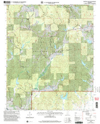
2000 Map of Whitten Town
USGS Topo · Published 2003About this map
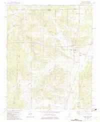
Holly Springs National Forest blankets much of this landscape along the border of Benton and Tippah counties at the start of the 21st century. The map centers on the small settlement of Whitten Town and the high point of Rogers Hill, surrounded by a dense network of country roads such as Blackjack Road and Ironcrafters Road. This area is defined by its deep-rooted rural communities, evidenced by numerous small churches and family burial grounds like Beech Hill Ch, Little Hope Ch, and Tate Cem. The topography is shaped by a complex drainage system including Shelby Creek and North Tippah Creek. In the southern portion of the quadrangle, the Crawford Lookout Tower stands near Lake Chautauqua, serving as a silent sentinel for forest management in this timber-rich region of northern Mississippi.
Find a feature on this map
52 named features on this map. Tap any name to fly to it.
Don’t see what you’re looking for? This feature index may not catch every label — zoom into the map to look around manually.
Map Details
Editions of this 2000 Whitten Town Map
This is the sole edition of this map. No revisions or reprints were ever made.
Other maps of this area

1950 · Ashland
USGS Topo · 1:62,500

1951 · Walnut
USGS Topo · 1:62,500

1955 · Ripley
USGS Topo · 1:62,500

1955 · Blue Mountain
USGS Topo · 1:62,500

1956 · Tupelo
USGS Topo · 1:250,000

1958 · Tupelo
USGS Topo · 1:250,000
1982 · Ripley
USGS Topo · 1:24,000
1982 · Blue Mountain
USGS Topo · 1:24,000
1982 · Chilli Creek
USGS Topo · 1:24,000
1982 · Walnut
USGS Topo · 1:24,000