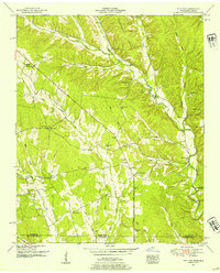
1951 Map of Whitten
USGS Topo · Published 1954About this map
Chisholm Road cuts a prominent diagonal across the landscape of Wayne County and Lauderdale County, linking small rural settlements like Crossroads and Fairview along the Tennessee-Alabama state line. The terrain is defined by the prominent Bucksnort Ridge and a dense network of waterways including Butler Creek, Cypress Creek, and Mill Branch. This 1951 field examination reveals a highly localized community structure, where numerous one-room schoolhouses and country churches such as Macedonia Ch, Robertson Sch, and Whitten Chapel served family clusters. Evidence of early industrial activity appears on the eastern edge with several Open Pit mines (Abd), while family cemeteries like Brewer Cem and Roberson Cem provide essential data points for genealogical research in this border region.
Find a feature on this map
54 named features on this map. Tap any name to fly to it.
Don’t see what you’re looking for? This feature index may not catch every label — zoom into the map to look around manually.
Map Details
Editions of this 1951 Whitten Map
2 editions found
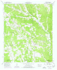
Other maps of this area

1905 · Waynesboro
USGS Topo · 1:125,000

1914 · Muscle Shoals
USGS Topo · 1:48,000

1916 · Muscle Shoals
USGS Topo · 1:62,500

1924 · Gravelly Springs
USGS Topo · 1:48,000

1926 · Gravelly Springs
USGS Topo · 1:62,500

1936 · Westpoint
USGS Topo · 1:24,000

1936 · Collinwood
USGS Topo · 1:24,000

1936 · Light
USGS Topo · 1:24,000

1936 · Threet
USGS Topo · 1:24,000

1936 · Cypress Inn
USGS Topo · 1:24,000