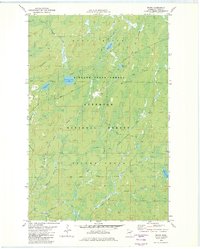
1982 Map of Whyte
USGS Topo · Published 1982About this map
Finland State Forest and the Superior National Forest dominate this Lake County landscape, where the local economy and geography were historically tied to the timber and mining industries. The Duluth Missabe and Iron Range railroad bisects the terrain, connecting small settlements like Whyte and Scott Junction. These locations served as critical nodes for transport in a region defined by its water systems, including the Stony River and Cloquet River.
Find a feature on this map
27 named features on this map. Tap any name to fly to it.
Don’t see what you’re looking for? This feature index may not catch every label — zoom into the map to look around manually.
Map Details
Editions of this 1982 Whyte Map
2 editions found
Other maps of this area

1953 · Whyte
USGS Topo · 1:62,500

1954 · Greenwood Lake
USGS Topo · 1:62,500

1954 · Silver Bay
USGS Topo · 1:62,500

1954 · Two Harbors
USGS Topo · 1:250,000

1955 · Isabella
USGS Topo · 1:62,500

1957 · Two Harbors
USGS Topo · 1:250,000

1958 · Two Harbors
USGS Topo · 1:250,000

1964 · Two Harbors
USGS Topo · 1:250,000

1976 · Two Harbors
USGS Topo · 1:100,000
1981 · Legler Lake
USGS Topo · 1:24,000