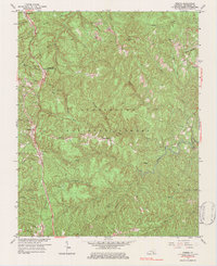
1963 Map of Wiborg
USGS Topo · Published 1984About this map
Cumberland National Forest dominates this McCreary County landscape, where the deeply dissected plateau creates a complex network of ridges and hollows. The Southern railroad serves as the primary spine for human activity, connecting the highland settlements of Greenwood, Parkers Lake, and Wiborg. These communities are often perched on the narrow crests between drainage basins like Coger Creek and Indian Creek.
Find a feature on this map
51 named features on this map. Tap any name to fly to it.
Don’t see what you’re looking for? This feature index may not catch every label — zoom into the map to look around manually.
Map Details
Editions of this 1963 Wiborg Map
3 editions found
Other maps of this area

1890 · Williamsburg
USGS Topo · 1:125,000

1894 · Williamsburg
USGS Topo · 1:125,000

1932 · Burnside
USGS Topo · 1:62,500

1934 · Barthell
USGS Topo · 1:62,500

1952 · Hail
USGS Topo · 1:24,000

1952 · Hollyhill
USGS Topo · 1:24,000

1952 · Wiborg
USGS Topo · 1:24,000

1952 · Cumberland Falls
USGS Topo · 1:24,000

1952 · Whitley City
USGS Topo · 1:24,000
1952 · Sawyer
USGS Topo · 1:24,000