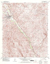
1964 Map of Wickenburg
USGS Topo · Published 1993About this map
The Hassayampa River carves a fertile valley through the arid landscape of central Arizona, acting as a corridor for both nature and transportation. In the early 1960s, the town of Wickenburg served as a regional hub where the Atchison Topeka and Santa Fe railroad met local arteries like Rincon Road and Constellation Road. The presence of the High Sch, a Hospital, and a Cemetery indicates a well-established community infrastructure at the foot of the Wickenburg Mountains.
Find a feature on this map
26 named features on this map. Tap any name to fly to it.
Don’t see what you’re looking for? This feature index may not catch every label — zoom into the map to look around manually.
Map Details
Editions of this 1964 Wickenburg Map
4 editions found
Other maps of this area

1887 · Prescott
USGS Topo · 1:250,000

1892 · Prescott
USGS Topo · 1:250,000

1903 · Congress
USGS Topo · 1:125,000

1904 · Congress
USGS Topo · 1:125,000

1947 · Wagoner
USGS Topo · 1:62,500

1948 · Wagoner
USGS Topo · 1:63,360

1950 · Wagoner
USGS Topo · 1:62,500

1950 · Prescott
USGS Topo · 1:250,000

1954 · Prescott
USGS Topo · 1:250,000

1954 · Phoenix
USGS Topo · 1:250,000