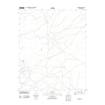
2011 Map of Wide Ruins
USGS Topo · Published 2011About this map
Wide Ruins serves as a focal point for this landscape in the early 21st century, where desert roads like Wide Ruins Loop and Pigeon Springs Rd converge in the Arizona high desert. The area is defined by its critical water sources, including Lichee Sinil Spring, Kinnazizi Spring, and Be He Lini Spring, which support life across a terrain marked by the Red Hills. The Twin Buttes Trading Post stands as a notable landmark along the winding network of Indian Routes that provide the primary infrastructure for the region. These routes, such as Indian Rte 9355, follow the natural contours of the land, navigating around drainages like Bent Knee Wash. The map reflects a modern record of habitation and resource management in the Fort Defiance Agency area, emphasizing the persistent importance of named springs and trading outposts.
Find a feature on this map
17 named features on this map. Tap any name to fly to it.
Don’t see what you’re looking for? This feature index may not catch every label — zoom into the map to look around manually.
Map Details
Editions of this 2011 Wide Ruins Map
This is the sole edition of this map. No revisions or reprints were ever made.
Other maps of this area

1886 · Fort Defiance
USGS Topo · 1:250,000

1892 · Fort Defiance
USGS Topo · 1:250,000

1954 · Gallup
USGS Topo · 1:250,000

1958 · Gallup
USGS Topo · 1:250,000

1959 · Gallup
USGS Topo · 1:250,000

1962 · Gallup
USGS Topo · 1:250,000

1967 · Gallup
USGS Topo · 1:250,000

1971 · Wide Ruins
USGS Topo · 1:24,000

1971 · Burntwater Wash
USGS Topo · 1:24,000
1971 · Tudecoz Spring
USGS Topo · 1:24,000