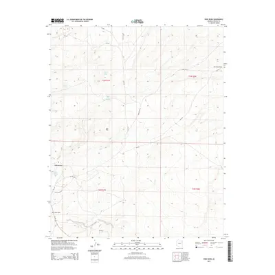
2014 Map of Wide Ruins
USGS Topo · Published 2014About this map
The settlement of Wide Ruins anchors this high-desert landscape within the Fort Defiance Agency, where traditional land use and water management are evident through a network of named springs. Critical water sources like Pigeon Spring Number Two, Lichee Sinil Spring, and Tom Joe Spring are dispersed throughout the terrain, suggesting a history of reliance on these specific points for livestock and community survival. The physical geography is defined by the Red Hills and the drainage patterns of Bent Knee Wash and Oak Ridge Wash. Transport routes such as Us 191 and the local Banana Wash Rd connect the area's residents, while Bureau of Indian Affairs routes like Bia-9356 provide interior access to the township sections of T24N and T23N. This 2014 survey records a landscape where geographic names often reflect personal or cultural identifiers, offering significant detail for those studying the intersection of geology and indigenous settlement patterns.
Find a feature on this map
24 named features on this map. Tap any name to fly to it.
Don’t see what you’re looking for? This feature index may not catch every label — zoom into the map to look around manually.
Map Details
Editions of this 2014 Wide Ruins Map
This is the sole edition of this map. No revisions or reprints were ever made.
Other maps of this area

1886 · Fort Defiance
USGS Topo · 1:250,000

1892 · Fort Defiance
USGS Topo · 1:250,000

1954 · Gallup
USGS Topo · 1:250,000

1958 · Gallup
USGS Topo · 1:250,000

1959 · Gallup
USGS Topo · 1:250,000

1962 · Gallup
USGS Topo · 1:250,000

1967 · Gallup
USGS Topo · 1:250,000

1971 · Wide Ruins
USGS Topo · 1:24,000

1971 · Burntwater Wash
USGS Topo · 1:24,000
1971 · Tudecoz Spring
USGS Topo · 1:24,000