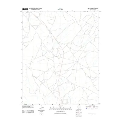
2011 Map of Wide Ruins SW
USGS Topo · Published 2011About this map
191 cuts diagonally through this high-desert landscape in the Fort Defiance Agency region, providing a modern spine for a vast network of local roads. The terrain is characterized by a sparse, branched drainage pattern and the distinct presence of La Pinta Mesa Rd, which traverses the western half of the quadrangle. As a modern US Topo sheet, this map highlights the contemporary road infrastructure essential for travel between remote points, including Burntwater Rd and numerous routes designated for the Navajo Nation, such as Indian Rte 9411 and Indian Rte 9404. The map illustrates a largely rural and open environment where transportation is defined by these long-distance corridors and unpaved connectors.
Find a feature on this map
8 named features on this map. Tap any name to fly to it.
Don’t see what you’re looking for? This feature index may not catch every label — zoom into the map to look around manually.
Map Details
Editions of this 2011 Wide Ruins SW Map
This is the sole edition of this map. No revisions or reprints were ever made.
Other maps of this area

1886 · Fort Defiance
USGS Topo · 1:250,000

1892 · Fort Defiance
USGS Topo · 1:250,000

1954 · Gallup
USGS Topo · 1:250,000

1958 · Gallup
USGS Topo · 1:250,000

1959 · Gallup
USGS Topo · 1:250,000

1962 · Gallup
USGS Topo · 1:250,000

1967 · Gallup
USGS Topo · 1:250,000

1971 · Wide Ruins
USGS Topo · 1:24,000

1971 · Burntwater Wash
USGS Topo · 1:24,000
1971 · Sanders
USGS Topo · 1:24,000