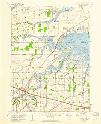
1957 Map of Wightmans Grove
USGS Topo · Published 1960About this map
The Sandusky River winds through the heart of this landscape, flanked by the low-lying marshes of Muddy Creek Bay and a network of intricate waterways like Yellow Swale and Green Creek. This mid-century survey captures the region as the Ohio Turnpike established a modern corridor across the southern township lines of Salem, Rice, and Riley. The area retains a rural, sportsman-oriented character, evidenced by the Green Creek Hunting Club and the river-bend settlement at Wightmans Grove.
Find a feature on this map
38 named features on this map. Tap any name to fly to it.
Don’t see what you’re looking for? This feature index may not catch every label — zoom into the map to look around manually.
Map Details
Editions of this 1957 Wightmans Grove Map
This is the sole edition of this map. No revisions or reprints were ever made.
Other maps of this area

1900 · Oak Harbor
USGS Topo · 1:62,500

1901 · Put-In-Bay
USGS Topo · 1:62,500

1901 · Bellevue
USGS Topo · 1:62,500

1901 · Fremont
USGS Topo · 1:62,500

1903 · Bellevue
USGS Topo · 1:62,500

1903 · Fremont
USGS Topo · 1:62,500

1903 · Put In Bay
USGS Topo · 1:62,500

1952 · Oak Harbor
USGS Topo · 1:24,000

1952 · Lacarne
USGS Topo · 1:24,000

1952 · Oak Harbor
USGS Topo · 1:62,500